Download PrettyMap & PrettyEarth for Palm OS
Ensure that you have read the license agreement before installing and using PrettyMap or PrettyEarth. By installing these applications you expressly consent to be bound by the terms and conditions of this agreement.
See the PrettyMap and PrettyEarth comparison table.
Downloads:
|
PrettyMap 5.5 for PalmOS Alternatively, you can download a single .prc file that can be directly transferred to your Palm device ("OTA" download, 4.2 MB). This installer contains a few maps and will automatically install PrettyMap on the device. |
PrettyEarth 5.5 for PalmOS Alternatively, you can download a single .prc file that can be directly transferred to your Palm device ("OTA" download, 4 MB). This installer contains a few maps and will automatically install PrettyEarth on the device. |
Revision history
 news feed, and if they preferred email notifications, they could register on our forum and subscribe to Announcements.
New in version 5.5:
- slightly faster displaying of vector maps
- fixed drawing of some vector maps: objects are now again sorted by importance (this was a bug since v5.3)
- improved default color styles for labels on vector area maps
- usability enhancements
- users who purchased version 4.x can upgrade to version 5.x for $10
New in version 5.4:
- new option, Auto-load maps (active by default), allows to automatically load raster maps (e.g. elevation or sat image tiles) most appropriate for the area you are viewing
- a message "...waiting for GPS fix..." appears when GPS is active, yet no coordinates have been received
- you can now use enter or space keys to zoom in, and backspace to zoom out
- shapefile-to-prettymap converter is much faster for shapefiles with many (e.g. more than 50,000) objects
- fixed a bug with exceeding top and bottom world boundaries while panning raster maps
- improved rules for colors of simple type labels on area maps
- slightly faster displaying of zoomed raster maps
- shapefile-to-prettymap converter can now convert encodings: from UTF-8 to Latin-1 (ISO 8859-1) and vice versa
New in version 5.3:
- fixed "Vector map layers/New map..." that would only work with another user map selected
- while editing text fields, the MENU key will now open a window with clipboard options: cut/copy/paste/clear
- while editing text fields, the ALT key on Treos will open a keyboard with special characters
- in the vector layers window, layer order has been reversed: top layer is now on top
- you can now open the vector layers window when no vector maps are open
- "move selected here" in context menu appears only for selected points on user maps
- removed the limit if 15000 objects per vector map layer
- faster loading of data in vector maps
- faster saving of user-editable maps
- improved memory management: you can open more vector maps
- fixed reporting of free memory in the "About" window
- fixed display issue when logging GPS locations
- "Search" can now be assigned to a hardware button
- improved synchronization window and a step-by-step sync procedure
- new LayerOrder field in map styles lets you influence/force ordering of vector maps of a given category (see the gfx/default.txt file for details)
- altitude is recorded in GPS log maps
- the GPX exporter now provides speed in m/s, not km/h
- PrettyMap-powered mobile apps can be used to edit geo-located records in customized relational databases (e.g. landmark types associated with locations associated with offices associated with people, etc.)
- numerous improvements in the user interface
New in version 5.2:
- improved labels in the "User locations" window
- layers (vector maps) are no longer rearranged when a session is restored
- user maps: fixed latitude when using the "Sun..." feature in the "Map locations" window
- user map bounding box is now correctly updated when using "Add point here..." in the context menu
- no longer adds two points when using "Add point here..." in the context menu and a new user map is created
- shortcuts are no longer visible on startup except for first runs
- removed "user maps" item in the menu; user maps can be maganed in the Vector/Layers... menu
- new, much faster editing of user maps
- new "remove" option in the context menu, when you click on a user location
- in the search window, previously searched map is now selected by default
- in the search window results, you can directly edit user locations
- you can now select a user map point and then easily move it to the desired location
- maximal zoom increased
- faster zoom in/zoom out
- much more frequent GPS tracking and logging is possible
- export to KML is now more flexible
- new: export to GPX
- improved synchronization
- supports network synchronization of user maps against a remote SQL database with OpenGIS/PostGIS extensions
- supports time synchronization/check
- converter from user points pmap to SQL (to insert your data in any SQL database)
- improvements in the user interface
New in version 5.1:
- better lat/lon grid
- new user location editor window: supports editing any number of attributes/values
- improved formatting of floating point values
- improved detection of modified values ("last modified" time stamp)
- improved generation of unique IDs for edited points
- more efficient use of some system resources
- improvements in the user interface
- shapefile-to-prettymap converter can produce editable point maps
New in version 5.0:
- built-in synchronization of user maps
- file format for vector maps has been enhanced; v5.x can read older maps
- improved support for some GPS units that previously caused "GPS signal lost" problems after 1-2 minutes of work
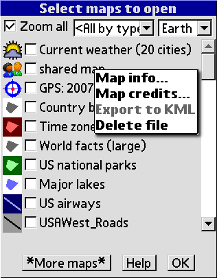
- redesigned "Open maps" window now shows icons for map categories
- you can filter maps by their main category
- you can filter out maps that are currently open
- checkboxes to select/deselect maps
- "User locations..." renamed to "Edit user maps..." and moved from the "Vector" menu to "Maps"
- persistent selection (i.e. after Search or Quick Find) – the selected object will remain red for 30 seconds
- "Draft mode" switch no longer affects automatic adjustments of shape fill. They are now always performed but less intrusive
- in the "Open maps" window, "Zoom all" is unchecked by default unless there are no maps opened
- better icon for GPS maps ("POI.GPS" category) and a new "Shared" category
- with GPS tracking, in case of Internet connection problems, attempts are made every minute
- improvements in the user interface